If geography was Greek in Antiquity, it was Arabic in the Middle Ages. At that time, in the Islamic world, great treatises on universal geography were written, and these writings were intimately linked to the existence of an empire that stretched from the Indus to the Pyrenees and spanned three continents. This powerful geographical discourse, written in Arabic, rehabilitates the medieval period as an essential moment in the constitution of the discipline
Emmanuelle Tixier du Mesnil
Université Paris-Nanterre

To understand the importance of Andalusi geographical production, it is first necessary to retrace the history of medieval Arab geography more generally. Until the work of André Miquel (d. 2022), works tracing the history of geographical thought generally ignored the Middle Ages. These books moved almost seamlessly from ancient geography to the Renaissance, when Humanism refocused thought on man and took a renewed interest in the space in which he lived.
The Middle Ages, regarded as obscurantist, would have produced no more than a few travel journals and portulans heralding discoveries yet to come. Yet, this period, which lasted over a thousand years, also developed an imago mundi, based on the reception of a rich ancient heritage that it was able to renew and extend. It was in the Islamic world, and not in the Latin West, that the ancient science of describing countries was revived, which perhaps explains the silence of histories of science that are still too often Eurocentric.
If geography was Greek in Antiquity, it was Arabic in the Middle Ages: no treatise on geography was written in the Latin West before the fourteenth century, with the exception of two manuscripts from the Carolingian period that brought together ancient knowledge but had no immediate posterity. In the Islamic world, however, great treatises on universal geography were written, and these writings are intimately linked to the existence of an empire that stretched from the Indus to the Pyrenees and spanned three continents. This powerful geographical discourse, written in Arabic, rehabilitates the medieval period as an essential moment in the constitution of the discipline. It was in Baghdad —especially in the ninth century— that many of the ancient texts found in the Hellenistic lands conquered by Islam were translated, at the very time when knowledge of Greek was declining in the West. This heritage, which is no more “Western” than the Byzantine lands in which it was found, was not left untouched. In 217/832, the Abbasid caliph al-Maʾmūn turned the House of Wisdom (bayt al-ḥikma) in Baghdad into a library where translators transposed into Arabic over a hundred Greek treatises on medicine, philosophy (including works by Aristotle and Plato), mathematics, astronomy, various sciences and geography, including the work of Ptolemy, the Alexandrian geographer of the second century CE, the Almagest, probably translated into Arabic a little earlier, around 183-184/800, as well as his Geography, Tables, Hypotheses of the Planets, Planisphere, also the Tables of Theon of Alexandria, the Geography of Marin of Tyre, and various ancient treatises.
André Miquel has shown that Arabic-language geography was not content simply to take over Greek science and pass it on to modernity. Far from being a mere repository of Hellenic science, it was enriched by data drawn from sources of the Persian representation of the world, and developed an original and profoundly innovative geographical discourse. Historians first turned these thousands of pages of geography into an immense reservoir of data, which they used to find specific information on the location of sites or the products of a region. André Miquel turned them into a veritable field of knowledge, which he endeavoured to explore in order to understand their originality, specific features, style and coherence.
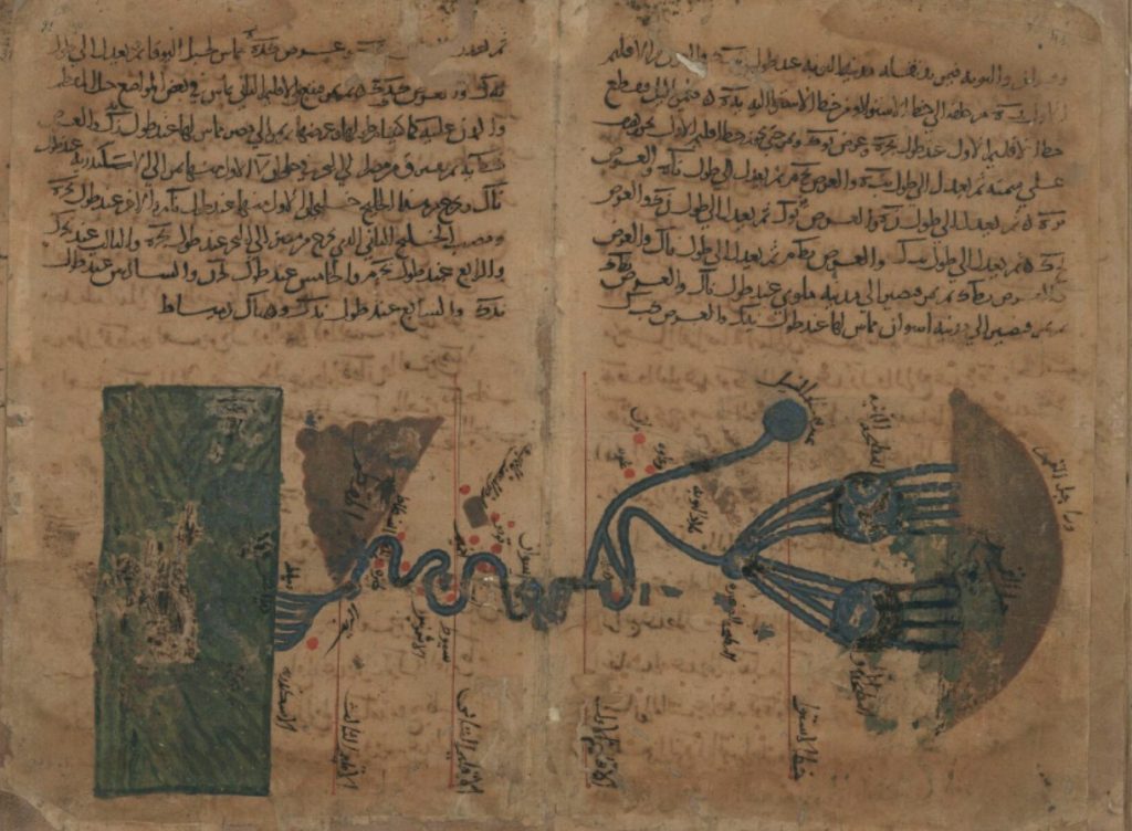
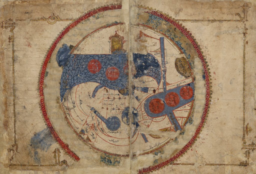
Miquel showed that this discipline was “the offspring of the Baghdad caliphate”, and traced its development from the ninth century, when the Arabic-language geography composed in Abbasid Baghdad set out to draw up a “cartography of the earth” (ṣūrat al-arḍ), popularising data that was originally astronomical and evolving into a literary genre, that of administrative geography for use by civil servants. The backbone of this discourse is the revival of the Greek division of the oecumene into seven climates,[1] the invention of which is attributed by Arabic-speaking scholars to Ptolemy. But this heritage is combined with that of ancient Persian geography, which presupposes a star-shaped distribution of the world around the central keswar, a zone stretching across Iran and Iraq; the centre is determined not by the conjunction of numbers, but by the history and influence of the place. The emerging Arab geography juxtaposed these ancient conceptions of the world and the theory of the seven climates evolved by introducing the notion of the centre, which was extended to the whole of the median climate, the fourth, that of the old country of Babylon which Islam had inherited, and gradually this median climate, that of the norm, came to cover a large part of the Islamic lands, within a geography that was becoming less and less mathematical. Geographical discourse, torn between literary requirements, the desire to remain “scientific” and the need to continue providing technical information, constantly oscillated between the pleasure of entertainment, the need for reflection and the desire to educate. It is a veritable “human geography”, to use the title of André Miquel’s work, which contributes to the education of the cultivated city-dweller of Cordoba, Damascus or Isfahan. The arithmetical nomenclature of the globe gives way to a discourse of general culture that enlivens the presentation of lands with anecdotes about kings, cities, diversity of peoples and marvels of creation of which these places were the theatre. At this point, the narratives far exceeded what the map could contain, and the scientific geography of the early days, the natural offspring of astronomy, slid towards adab (Belles Lettres), as witnessed in particular by the works of the school of al-Kindī (d. after 256/870).
A major turning point came in the 900s, with the geography known as al-masālik wa-l-mamālik (“routes and realms”). Ibn al-Faqīh, in a work composed in 290/903, the Kitāb al-buldān, chose to present scattered data country by country and to adopt spatial coherence: the framework was henceforth defined by the succession of places. The treatises of al-Balkhī (d. 322/934), al-Iṣtakhrī (d. c. 340/951), Ibn Ḥawqal (d. after 377/988) and al-Muqaddasī (d. after 381/991), the two greatest oriental geographers, take up the previous works, reorganise them, and refocus them on their geographical purpose. The masālik gave a new meaning to the old Greek term for climate: the iqlīm (a transposition of the Greek klima) was no longer one of the seven zones of the inhabited world, but a province of the Islamic world. The tenth century was the golden age of this imperial and universal geography, which primarily described the world of Islam. The first major innovation compared with the previous century and with the genre of the ṣūrat al-arḍ, the “new geographers” of the tenth century considered travel as one of the means of gaining access to knowledge; the fruits of personal observation (ʿiyān) were confronted with data drawn from book information.
The second major innovation is that geography is now solely concerned with Islam’s empire, the mamlakat al-islām, which stretches from the great surrounding ocean to the wall of Gog and Magog, the two mythical limits of the world; exotic lands, formerly the favourite subjects of descriptions of the inhabited earth (ṣūrat al-arḍ), are downgraded to a marginal status and are interesting only insofar as they bear witness to what Islam is not. The strange is now confused with the foreign. However, the need to entertain the reader makes anecdotes about them necessary. The paradox of this new geography centred on the Islamic empire is that it came into being at the beginning of the tenth century, at a time when the unity of the empire had disappeared. There was no longer a single caliphate, but three rival caliphates, due to the proclamation of two new caliphates (the Fatimid caliphate, proclaimed in Kairouan in 296/909, and the Umayyad caliphate in Cordoba, from 316/929), which disputed not only the Abbasid dynasty’s leadership of the Islamic world, but also the development of history and an image of the world.
Geographical discourse attempted to maintain the fiction of the unity of Islam by making roads and itineraries (masālik) the links between the provinces of the former mamlaka in order to transcend political and military divisions. Through their global studies, geographers affirmed the cultural, religious and economic unity of a whole that was no longer a single empire but the countries of Islam, an area now united in different ways and tirelessly traversed by pilgrims, spies, adventurers of all kinds, missionaries, merchants and scholars. It is perhaps one of the most powerful and effective attempts to maintain unity, that obsession of the Arab Middle Ages, even as divisions were at work.
From the early eleventh century onwards, however, as the caliphates faded and the Turks in the east and the Berbers in the west rose to power, no great treatises of universal geography were written in the East. Instead, regional monographs, geographical dictionaries (such as Yāqūt’s Muʿjam al-buldān in the early thirteenth century)[2] and travel diaries (riḥla) were written. The disappearance of the mamlaka, according to André Miquel, rendered the imperial geography of the preceding period obsolete, and it is at this chronological threshold that he closes his study. But universal geography in Arabic did not disappear; it was now written in the West of the Islamic world, mainly in al-Andalus, the Maghreb and Sicily, in what André Miquel calls “the Western revival”.[3]
It is this Western, or Andalusi, geography that we need to analyse in order to measure its scope. It is important to understand that we are dealing here with the same kind of writing, with participation in the same global project of inventorying the oekoumene, and not with a geography that is specifically Andalusi, and therefore fundamentally different from the Arabic-language geography composed in the East. This intellectual endeavour can be compared to that of the European Enlightenment of the eighteenth century, a vast intellectual movement that knew no borders and was exemplified by scholars writing in different languages and different countries, but united by a common quest for science and reason. The difference, however, is that Baghdad geography and Andalusi geography were written in the same language, Arabic, and the similarities are even more obvious than in the case of the Enlightenment of the eighteenth century. It is therefore an extension, rather than a reworking, of Baghdad’s geography, with the primary aim of repairing the shortcomings of Baghdad’s geography of the West of the Islamic world. And rather than an ‘Andalusi’ geography, we should be talking about a universal geography written after the year 1000.[4]
Let us quickly introduce the authors who distinguished themselves in al-Andalus in this exercise. The first of these is undoubtedly Aḥmad al-Rāzī, more because of the role he played in developing a geographical adab on al-Andalus than because of his work, which is not a treatise on geography. It is in fact a geographical introduction to a universal history celebrating the glory of the Umayyads of Cordoba. This geographical introduction is quite unique in that it makes al-Andalus the projection in miniature of the entire Islamic world.[5] But even in its choice to describe only al-Andalus, it obeys the canons of description of the entire Islamic world. This work is seminal because al-Rāzī, who was born in al-Andalus in 274/888 and died there in 344/955, is the first Andalusi author to have described this land in detail. Born into a family originally from Rayy, who came to settle in al-Andalus in the middle of the third/ninth century and succeeded in occupying positions close to Umayyad power, al-Rāzī wrote at a time when the Caliphate of Cordoba was proclaimed in 316/929. In the same way that eastern geography had served the Abbasid caliphate in Baghdad, geography written in al-Andalus was inseparable from the Umayyad caliphate. Thus al-Rāzī endowed al-Andalus with an adab of its own, a geographical discourse that had barely developed when only Eastern authors wrote works of geography.
The aim of his pages of geography is not to describe, but to make an inventory of what was already known. The aim is to show that the masters he serves, the Umayyads of Córdoba, control the whole of the territory, with the enumeration of places being tantamount to asserting their possession. Al-Rāzī presents the singularity of al-Andalus, not in order to individualise it in a supposed destiny of its own, but to better testify that it is one of the jewels of the Islamic world and that, from its soil, the universal message of the caliphs can radiate. His comprehensive overview of Andalusi resources and provinces, compared with the most famous lands in the Islamic world, predates the works of Ibn Ḥawqal and al-Muqaddasī by several decades; it was compiled in the centuries that followed by the leading Andalusi geographers after the beginning of the early eleventh century, the same ones who would take up the genre of the universal geography treatise, describing the whole oekoumene and no longer the Andalusi territory alone.
The first to return to the genre of universal geography was al-ʿUdhrī (393-478/1003-1085), who lived most of his life in Almeria, where he witnessed the fitna, the civil war that saw the caliphate of Cordoba disappear and the Taifas, autonomous principalities whose history occupies the whole of the eleventh century, rise from the rubble of its territory. In the service of the Banū Ṣumādiḥ dynasty, he composed a work of geography that revived the description of all the countries of Islam, although the title of his main work is not known for certain: Niẓām al-marjān fī al-masālik wa-l-mamālik according to the oriental geographer Yāqūt, Kitāb Masālik wa-l-mamālik al-sharqiyya wa-kitāb al-masālik wa-l-mamālik al-gharbiyya for Ibn al-Athīr; the Jerusalem manuscript discovered by Dr Al-Ahwānī in the early 1960s, meanwhile, is entitled Tarṣīʿ al-akhbār wa-tanwīʿ al-āthār wa-l-bustān fī-gharāʼib al-buldān wa-l-masālik ilā jamīʿ al-mamālik (“The encrustation of history and the multiplicity of remains, the garden of curiosities and itineraries to all kingdoms”). What all these titles have in common is that they take up the ancient Baghdadian concept of “itineraries and states”, al-masālik wa-l-mamālik. The forty-eight folia preserved in Jerusalem are those devoted to the Iberian Peninsula, as it must have been mistakenly thought that the author had nothing to teach Syrian readers about the East, who consequently truncated the Tarṣīʿ. Now, as Gabriel Martinez-Gros points out, “this selection is no less regrettable because it confines the work to the narrow and subordinate field of local geography from which, precisely, al-ʿUdhrī was one of the first Andalusis to want to emerge”.[6] The ambition of this vast fresco is to emphasise the community of culture and language on the scale of the world of Islam. In his picture of the Iberian Peninsula, he focuses on the Taifas governed by rulers of Arab origin, to show the extent to which al-Andalus remained an Arab island, between the Berber Maghreb and the barbarian states of the north, despite the wreck of the Umayyads and the wars that tore these principalities apart. Another of his merits is to present the mirabilia (ʿajāʾib) of al-Andalus and to multiply the entertaining anecdotes, further enriching Andalusi adab, which would later be extensively anthologised, particularly by Eastern geographers.
Al-Bakrī (405-487/1014-1094) is undoubtedly the greatest Arab-language geographer of the post-Millenium period. He only briefly describes the Andalusi land in which he was born, which may seem paradoxical at first glance, but is explained by his plan to draw a bigger picture. He decisively unveiled the history and geography of the Maghreb in his Kitāb al-masālik wa-l-mamālik (composed in 460/1068), highlighting the potential of this region, as a new source of the lifeblood of Islam. It was at this time that the Almoravid Berbers established themselves in the west of the Maghreb (they founded Marrakesh in 462/1070); twenty years later, they imposed themselves in the Iberian Peninsula by inflicting on Alfonso VI of Castile one of his greatest defeats, that of Zallāqa in 479/1086. In this picture, the Maghreb is finally given the place it deserves, while the Latin West is revealed for the first time. Under the pen of this geographer, al-Andalus is no more than an outpost of Islam, on the defensive. This important author was widely compiled by later geographers, both in al-Andalus and in the East.
Notes:
[1] Klima, in Greek, means inclination. A climate is a space defined by the inclination of the sun in relation to the horizon.
[2] However, this work is a dictionary, a vast summary, not a treatise that sets out to divide the world into provinces, climates or countries, and to describe it according to a spatial logic.
[3] A. Miquel, “La géographie arabe après l’an mil,” in Popoli e paesi nella cultura altomedievale: XXIX settimane di studio del Centro italiano di studi sull’alto medioevo, 23-29 aprile 1981 (Spoleto: Centro Italiano di Studi sull’Alto Medioevo, 1983), 153–74.
[4] E. Tixier du Mesnil, Géographes d’al-Andalus. De l’inventaire d’un territoire à la construction d’une mémoire (Paris: Publications de la Sorbonne, 2014), 52 et sq.
[5] This book, whose Arabic original was lost, has come down to us through a fourteenth-century Portuguese translation, and thanks to a patient reconstruction by Lévi-Provençal 1953: 51–108.
[6] G. Martinez-Gros, L’idéologie omeyyade (Madrid: Casa de Velázquez, 1992), 230 et seq.
Further reading:
Primary sources:
- Abū al-Fidāʾ. Géographie d’Aboulféda. Translated by M. Reinaud. Paris: Imprimerie Nationale, 1848.
- ———. Taqwîm al-buldân, géographie d’Abulféda. Edited by M. Reinaud and Baron de Slane. Paris: Imprimerie Royale, 1840.
- al-Bakrī. Kitāb al-Masālik wa-l-mamālik. Edited by A. P. van Leeuwen and A. Ferré. Tunis: al-Dār al-ʿArabiyya li-l-Kitāb and Bayt al-Ḥikma, 1992.
- al-Ḥimyarī. Kitāb al-Rawḍ al-miʿṭār. Edited by I. ʿAbbās. Beirut: Maktabat Lubnān, 1984.
- Ibn Khurradādhbih [Ibn Khorradādhbeh]. Kitāb al-Masālik wa-l-mamālik. Edited by De Goeje. Leiden: Brill, 1889. Bibliotheca Geographorum Arabicorum 6.
- Ibn Rustah [Ibn Rosteh]. Kitāb al-Aʿlāk an-nafīsa. Edited by M. J. de Goeje. Leiden: Brill, 1892. Bibliotheca Geographorum Arabicorum 7.
- ——— [Ibn Rusteh]. Les atours précieux. Translated by Gaston Wiet. Cairo: Publications de la Société de géographie d’Egypte, 1955.
- al-Idrīsī. Kitāb Nuzhat al-mushtāq fī ikhtirāq al-āfāq, Opus geographicum, sive, Liber ad eorum delectationem qui terras peragrare studeant. Edited by Enrico Cerulli. Leiden: Brill, 1970-78.
- ———. La première géographie de l’Occident. Translated by Annliese Nef and Henri Bresc. Paris, GF Flammarion, 1999.
- Lévi-Provençal, É. “La Description de l’Espagne de al-Rāzī.” Al-Andalus 18 (1953): 51–108.
- ———. La Péninsule Ibérique au Moyen-Age d’après le Kitāb ar-Rawḍ al-miʿṭār fī ḫabar al-aḳṭār d’Ibn ʿAbd al-Munʿim al-Ḥimyarī. Leiden: Brill, 1938.
- Miquel, A. La meilleure répartition pour la connaissance des provinces (Aḥsan al-taqāsīm fī maʿrifat al-aqālīm). Damascus: Publications de l’Institut Français de Damas, 1963.
- al-Qazwīnī, Zakarīyā b. Muḥammad. Kitāb ʿAjāʾib al-makhlūqāt = Zakarija Ben Mohammad Ben Mahmud el-Cazwini. Kosmographie. Vol. 1. Edited by Ferdinand Wüstenfeld. Göttingen: Verlag der Dieterichschen Buchhandlung, 1848.
- ———. Āthār al-bilād wa-akhbār al-ʿibād. Beirut: Dār Ṣādir, 1380/1960.
- Yāqūt al-Ḥamawī. Muʿjam al-buldān. Edited by Ferdinand Wüstenfeld. Leipzig: F. A. Brockhaus, 1866-1873.
- ———. Muʿjam al-buldān. Edited by Farīd ʿAbd al-ʿAzīz al-Jundī. Beirut: Dār al-Kutub al-ʿIlmiyya, 1990.
Reference works:
- ʿAbd al-Karīm, Gamal. La España musulmana en la obra de Yāqūt (s. XII-XIII). Repertorio enciclopédico de ciudades, castillos y lugares de al-Andalus, extraído del Muʿjam al-buldān (Diccionario de los países). Cuadernos de Historia del Islam, Serie Monográfica-Islámica Occidentalia 6. Granada: Publicaciones del Seminario de Historia del Islam de la Universidad de Granada, 1974.
- Antrim, Zayde. Routes and Realms: The Power of Place in the Early Islamic World. New York: Oxford University Press, 2012.
- De la Granja, F. La Marca superior en la obra de al-ʿUdrí. Zaragoza: Escuela de Estudios Medievales-Consejo Superior de Investigaciones Científicas, 1966.
- Franco-Sánchez, F. “‘Al-Masālik wa-l-Mamālik’: Precisiones acerca del título de estas obras de la literatura geográfica árabe medieval y conclusiones acerca de su origen y estructura.” Philologia Hispalensis 31, 2 (2018) : 37–66.
- Ducène, J. C. L’Europe et les géographes arabes du Moyen Âge. Paris, CNRS éditions, 2018.
- Hartog,François. Mémoire d’Ulysse. Récits sur la frontière en Grèce ancienne. Paris: Gallimard, 1996.
- Kratchkovsky, I. “Les géographes arabes des XIe et XIIe siècles en Occident.” Annales de l’Institut d’études orientales de l’Université d’Alger 18-19 (1960-1961), 1–72.
- Martinez-Gros, Gabriel. L’idéologie omeyyade. Madrid: Casa de Velázquez, 1992.
- Micheau, F. “Les institutions scientifiques dans le Proche-Orient médiéval.” In Histoire des sciences arabes, ed. R. Rashed, 3:233–54. Paris: Seuil, 1997.
- Miquel, A. “La géographie arabe après l’an mil.” In Popoli e paesi nella cultura altomedievale: XXIX settimane di studio del Centro italiano di studi sull’alto medioevo, 23-29 aprile 1981. Spoleto: Centro Italiano di Studi sull’Alto Medioevo, 1983, 153–74.
- ———. La géographie humaine du monde musulman jusqu’au milieu du 11e siècle. Leiden: Brill, 1967-1988.
- Molina, Luis. «Orosio y los geógrafos hispanomusulmanes.» Al-Qantara V, 1-2 (1984), 63-92.
- Molina López, E. La cora de Tudmīr según al-ʿUḏrī. Cuadernos de Historia del Islam. Serie Monográfica-Islámica Occidentalia 4. Granada: Publicaciones del Seminario de Historia del Islam de la Universidad de Granada, 1972.
- Muʾnis, Ḥ. “Al-Jughrāfiyya wa-l-jughrāfiyyūn fī al-Andalus.” Revista del Instituto de Estudios Islámicos 7-8 (1959-1960): 199–359 (Arabic Section).
- Pons Boigues, F. Ensayo biobibliográfico sobre los historiadores y geógrafos arábigo-españoles. Madrid, 1898.
- Roldán, Fátima and Rafael Valencia. “El género al-masālik wa-l-mamālik: Su realización en los textos de al-ʿUḏrī y al-Qazwīnī sobre el Occidente de al-Andalus.” Philologia Hispalensis 3 (1988): 7–25.
- Sánchez-Albornoz, C. Investigaciones sobre historiografía hispana medieval (siglos VIII al XII). Buenos Aires: Instituto de Historia de España, 1967.
- Sánchez Martínez, M. “La Cora de Ilbîra (Granada y Almería) en los siglos X y XI, según al-ʿUḏrī (1003-1085). Traducción y notas.” Cuadernos de Historia del Islam 7 (1975-1976): 5–82.
- ———. “Rāzī, fuente de al-ʿUḏrī para la España preislámica.” Cuadernos de Historia del Islam 3 (1971): 7–49.
- Staszak, J. F. La géographie d’avant la géographie. Le climat chez Aristote et Hippocrate. Paris: Editions L’Harmattan, 1995.
- Tixier du Mesnil, E. Géographes d’al-Andalus. De l’inventaire d’un territoire à la construction d’une mémoire. Paris: Publications de la Sorbonne, 2014.
- ———. “Regards croisés sur Hispan/Ishbân, héros éponyme énigmatique de l’Espagne d’après les sources médiévales arabes et latine.” Studia Islamica 102 (2006): 199–216.
- Valencia, R., “La cora de Sevilla en el Tarṣīʿ al-ajbār de Aḥmad ibn ʿUmar al-ʿUḏrī.” Andalucía islámica. Textos y Estudios 4-5 (1986): 107–43.